Šiprage
Appearance


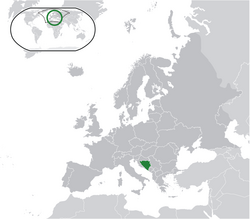
Šiprage (Шипраге) na siti mai Bosnia & Herzegovina. 788 (2013) 'ei wilika kai.[1][2]
- Latitudo: 44°27'56″
- Longitudo: 17°33'36″
- Altitudo: 507-520 m
Climat
[veisau | edit source]References
[veisau | edit source]- ↑ http://www.kartabih.com/
- ↑ Vojnogeografski institut, Ed. (1962): Šiprage (List karte 1:25.000, Izohipse na 10 m). Vojnogeografski institut, Beograd / Military Geographical Institute, Ed. (1962): Šiprage (map sheet 1: 25.000, Contour lines at 10 m). Military Geographical Institute, Belgrade.
- ↑ https://en.climate-data.org/location/905786/
Internet
[veisau | edit source]| Wikimedia Commons has media related to: Šiprage |
- http://opstinakotorvaros.com/
- http://www.maplandia.com/bosnia-and-herzegovina/republika-srpska/siprage/ Maplandia
- http://www.satellitecitymaps.com/europe-map/bosnia-and-herzegovina-map/federation-of-bosnia-and-herzegovina-map/%C5%A1iprage-map/
- http://www.distancesfrom.com/distance-from-Siprage-to-Banja-Luka-Bosna-i-Hercegovina/DistanceHistory/5243320.aspx
- http://www.udaljenosti.com/bosna/- Distances in B&H

